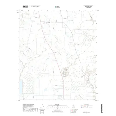
2019 Map of Simmons Bottom
USGS Topo · Published 2019About this map
Ryan Cem sits in the northern reaches of this Liberty County landscape, a vital landmark for family researchers tracing early residents near the junction of Co RD 300 and Co RD 2311. The terrain is defined by an intricate network of waterways, including the winding course of Luce Bayou and the confluence of Tarkington Bayou in the west. These drainage systems, alongside Indian Gulley and Prairie Marsh Gully, reveal the hydrological character of the Simmons Bottom area. The map illustrates a transition from agricultural and wooded tracts to residential developments like Eastwood Park, while names such as Blue Stem and Long John Cr anchor the local geography. A dense grid of county roads and state routes like FM 1008 shows how modern connectivity has shaped this part of the Texas Gulf Coast plain.
Find a feature on this map
57 named features on this map. Tap any name to fly to it.
Don’t see what you’re looking for? This feature index may not catch every label — zoom into the map to look around manually.
Map Details
Editions of this 2019 Simmons Bottom Map
This is the sole edition of this map. No revisions or reprints were ever made.
Other maps of this area

1916 · Huffman
USGS Topo · 1:24,000

1920 · Huffman
USGS Topo · 1:31,680

1943 · Liberty
USGS Topo · 1:125,000

1954 · Beaumont
USGS Topo · 1:250,000

1955 · Rayburn
USGS Topo · 1:62,500

1955 · Liberty
USGS Topo · 1:62,500

1957 · Beaumont
USGS Topo · 1:250,000

1958 · Cleveland
USGS Topo · 1:24,000

1959 · Plum Grove
USGS Topo · 1:24,000
1960 · Huffman
USGS Topo · 1:24,000