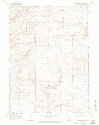
1968 Map of Simpson Gulch SW
USGS Topo · Published 1971About this map
Industrial exploration of the arid High Desert characterizes this survey of the Simpson Gulch SW quadrangle. Situated in Sweetwater County, the terrain is defined by its isolation and the systematic mapping of subsurface resources during the late 1960s. The landscape is dotted with evidence of energy exploration, most notably marked by the Little Colorado Well No 11 and Little Colorado Well No 12. These specific sites, along with a solitary Drill Hole, indicate a period of intense geological investigation into the oil and gas potential of the region. The map meticulously records the township and range lines, including the transition between T. 25 N. T. 24 N. and T. 24 N. T. 23 N., which served as the primary framework for land claims and mineral rights in this remote corner of Wyoming.
Find a feature on this map
6 named features on this map. Tap any name to fly to it.
Don’t see what you’re looking for? This feature index may not catch every label — zoom into the map to look around manually.
Map Details
Editions of this 1968 Simpson Gulch SW Map
2 editions found
Other maps of this area

1954 · Rock Springs
USGS Topo · 1:250,000

1955 · Lander
USGS Topo · 1:250,000

1958 · Lander
USGS Topo · 1:250,000

1958 · Rock Springs
USGS Topo · 1:250,000

1961 · Lander
USGS Topo · 1:250,000

1962 · Rock Springs
USGS Topo · 1:250,000

1963 · Gasson Bridge
USGS Topo · 1:24,000

1963 · Pittman Well
USGS Topo · 1:24,000
1963 · Thoman School
USGS Topo · 1:24,000
1968 · Twelvemile Sink
USGS Topo · 1:24,000