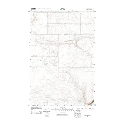
2011 Map of Sims Corner
USGS Topo · Published 2011About this map
Sims Corner serves as the central point of this high-plateau landscape in Douglas County, where the topography is defined by the sharp escarpments of coulees and the engineered water systems of the Columbia Basin Project. The local infrastructure is highlighted by the Sims Coner Dam and the associated Sims Corner Reservoir, which support the agricultural needs of this arid region. The map reveals a strict rectilinear grid of rural roads, such as 14 RD Ne and Murphy RD NE, which partition the land between natural depressions and seasonal water bodies. Significant geological features include the deep drainage of Banks Lake in the southeast corner and the smaller basins of Horse Lake and Ludtke Lake, reflecting a terrain shaped by ancient glacial floods and modern irrigation efforts.
Find a feature on this map
21 named features on this map. Tap any name to fly to it.
Don’t see what you’re looking for? This feature index may not catch every label — zoom into the map to look around manually.
Map Details
Editions of this 2011 Sims Corner Map
This is the sole edition of this map. No revisions or reprints were ever made.
Other maps of this area

1930 · Grand Coulee Sheet 3
USGS Topo · 1:31,680

1953 · Ritzville
USGS Topo · 1:250,000

1959 · Ritzville
USGS Topo · 1:250,000

1965 · Ritzville
USGS Topo · 1:250,000

1965 · St. Andrews
USGS Topo · 1:24,000

1965 · Mold
USGS Topo · 1:24,000

1968 · Steamboat Rock SW
USGS Topo · 1:24,000

1968 · Barker Canyon
USGS Topo · 1:24,000
1968 · Barnes Butte
USGS Topo · 1:24,000

1968 · Foster Coulee
USGS Topo · 1:24,000