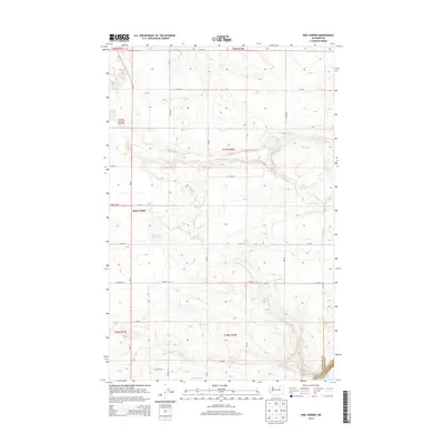
2014 Map of Sims Corner
USGS Topo · Published 2014About this map
Sims Corner serves as the central focal point of this 2014 survey, situated at the intersection of Wa-17 and Road 14 NE. This high-plateau landscape in Central Washington is defined by a grid-like network of rural roads such as Murphy Rd NE and Hayden Rd NE, which organize the agricultural and open lands of the region. Water resources are prominent features in this dry environment, ranging from the localized Sims Corner Reservoir and Horse Lake to the significant presence of Banks Lake along the eastern boundary. The map also delineates the jurisdictional transition between Douglas Co and Grant Co, providing a clear view of the cadastral divisions and township boundaries that have structured the area's development for over a century.
Find a feature on this map
27 named features on this map. Tap any name to fly to it.
Don’t see what you’re looking for? This feature index may not catch every label — zoom into the map to look around manually.
Map Details
Editions of this 2014 Sims Corner Map
This is the sole edition of this map. No revisions or reprints were ever made.
Other maps of this area

1930 · Grand Coulee Sheet 3
USGS Topo · 1:31,680

1953 · Ritzville
USGS Topo · 1:250,000

1959 · Ritzville
USGS Topo · 1:250,000

1965 · Ritzville
USGS Topo · 1:250,000

1965 · St. Andrews
USGS Topo · 1:24,000

1965 · Mold
USGS Topo · 1:24,000

1968 · Steamboat Rock SW
USGS Topo · 1:24,000

1968 · Barker Canyon
USGS Topo · 1:24,000
1968 · Barnes Butte
USGS Topo · 1:24,000

1968 · Foster Coulee
USGS Topo · 1:24,000