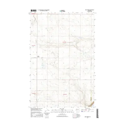
2017 Map of Sims Corner
USGS Topo · Published 2017About this map
Sims Corner serves as the focal point for this high-plateau region of Central Washington, situated at the intersection of a vast network of section roads. The landscape is defined by the dramatic descent into the Grand Coulee at the southeastern edge of the quadrangle, where the Douglas Co and Grant Co line meets the waters of Banks Lake. This area reflects a mid-century irrigation and agricultural legacy, evidenced by several water features scattered across the terrain, including Horse Lake, Ludtke Lake, and the specifically developed Sims Corner Reservoir. The grid-like road system, featuring routes like Leahy Rd S and 10th Rd NE, underscores the organized land management and ranching character of the territory during this era.
Find a feature on this map
22 named features on this map. Tap any name to fly to it.
Don’t see what you’re looking for? This feature index may not catch every label — zoom into the map to look around manually.
Map Details
Editions of this 2017 Sims Corner Map
This is the sole edition of this map. No revisions or reprints were ever made.
Other maps of this area

1930 · Grand Coulee Sheet 3
USGS Topo · 1:31,680

1953 · Ritzville
USGS Topo · 1:250,000

1959 · Ritzville
USGS Topo · 1:250,000

1965 · Ritzville
USGS Topo · 1:250,000

1965 · St. Andrews
USGS Topo · 1:24,000

1965 · Mold
USGS Topo · 1:24,000

1968 · Steamboat Rock SW
USGS Topo · 1:24,000

1968 · Barker Canyon
USGS Topo · 1:24,000
1968 · Barnes Butte
USGS Topo · 1:24,000

1968 · Foster Coulee
USGS Topo · 1:24,000