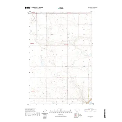
2020 Map of Sims Corner
USGS Topo · Published 2020About this map
Sims Corner serves as a lonely landmark in this high plateau landscape of Douglas County, where the geometric precision of the Public Land Survey System meets a terrain carved by ancient glacial floods. The map captures a transition in water management and geography, showing the edge of the Douglas and Grant county line near the northern reaches of Banks Lake. This area is characterized by scattered depressional water bodies like Horse Lake and Ludtke Lake, which punctuate a massive grid of agricultural service roads including Rd 11 NE and Leahy Rd S. The drainage patterns and coulee formations reflect the unique geology of the Channeled Scablands, providing a clear record of the rural infrastructure supporting the region's dryland farming and water storage networks.
Find a feature on this map
22 named features on this map. Tap any name to fly to it.
Don’t see what you’re looking for? This feature index may not catch every label — zoom into the map to look around manually.
Map Details
Editions of this 2020 Sims Corner Map
This is the sole edition of this map. No revisions or reprints were ever made.
Other maps of this area

1930 · Grand Coulee Sheet 3
USGS Topo · 1:31,680

1953 · Ritzville
USGS Topo · 1:250,000

1959 · Ritzville
USGS Topo · 1:250,000

1965 · Ritzville
USGS Topo · 1:250,000

1965 · St. Andrews
USGS Topo · 1:24,000

1965 · Mold
USGS Topo · 1:24,000

1968 · Steamboat Rock SW
USGS Topo · 1:24,000

1968 · Barker Canyon
USGS Topo · 1:24,000
1968 · Barnes Butte
USGS Topo · 1:24,000

1968 · Foster Coulee
USGS Topo · 1:24,000