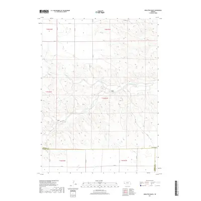
2017 Map of Singleton Ranch
USGS Topo · Published 2017About this map
The Lawrence Fork drainage system carves through the high plains of western Nebraska, defining the topography of this cattle country. In the southern portion of the quadrangle, the eponymous Singleton Ranch sits along Singleton Rd, representing the established ranching heritage of Cheyenne and Kimball counties. The terrain is marked by distinctive features such as Rocky Hollow and a network of section-line roads, including Hackberry Rd and various county routes that navigate the township and range divisions of the Nebraska Panhandle. The map illustrates the convergence of multiple county lines, showing the intersection of Banner Co, Kimball Co, and Cheyenne Co. This rural landscape remains largely defined by its natural watercourses and the large-scale landholdings necessary for ranching in this arid region.
Find a feature on this map
24 named features on this map. Tap any name to fly to it.
Don’t see what you’re looking for? This feature index may not catch every label — zoom into the map to look around manually.
Map Details
Editions of this 2017 Singleton Ranch Map
This is the sole edition of this map. No revisions or reprints were ever made.
Other maps of this area

1898 · Scotts Bluff
USGS Topo · 1:125,000

1898 · Camp Clarke
USGS Topo · 1:125,000

1954 · Scottsbluff
USGS Topo · 1:250,000

1958 · Scottsbluff
USGS Topo · 1:250,000

1973 · Potter 2 SW
USGS Topo · 1:24,000

1973 · Scotts Bluff 4 SE
USGS Topo · 1:24,000

1973 · Kimball 1 SE
USGS Topo · 1:24,000

1973 · Kimball 1 NE
USGS Topo · 1:24,000

1973 · Potter 2 SE
USGS Topo · 1:24,000

1973 · Potter 2 NW
USGS Topo · 1:24,000