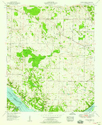
1954 Map of Sinking Creek
USGS Topo · Published 1958About this map
Pickwick Lake and the Tennessee River define the southern landscape of this mid-century survey, marking the boundary between Lauderdale and Colbert Counties. The terrain is characterized by a complex network of wetlands and karst features, most notably the extensive Harding Bottoms and Bell Sink. This area, mapped shortly after the mid-century, reveals a densely settled rural community connected by the Gunwaleford Road and Mud Road. Genealogists will find a wealth of local data, with numerous family-named cemeteries such as Sherrod Cem, Walston Cem, and Winborn Cem scattered across the uplands. The distribution of small country churches and schools like New Hope Ch, Canaan Ch, and Ray Sch reflects the social centers of the era before the consolidation of rural infrastructure. Significant crossroads like Lovelace Crossroads and Kimbrough Crossroads serve as the primary anchors for the scattered homesteads of Northwest Alabama.
Find a feature on this map
71 named features on this map. Tap any name to fly to it.
Don’t see what you’re looking for? This feature index may not catch every label — zoom into the map to look around manually.
Map Details
Editions of this 1954 Sinking Creek Map
4 editions found
Other maps of this area

1914 · Muscle Shoals
USGS Topo · 1:48,000

1916 · Muscle Shoals
USGS Topo · 1:62,500

1924 · Tuscumbia
USGS Topo · 1:48,000

1924 · Gravelly Springs
USGS Topo · 1:48,000

1925 · Barton
USGS Topo · 1:62,500

1926 · Tuscumbia
USGS Topo · 1:62,500

1926 · Barton
USGS Topo · 1:48,000

1926 · Gravelly Springs
USGS Topo · 1:62,500

1929 · Barton
USGS Topo · 1:62,500

1935 · Cherokee
USGS Topo · 1:24,000