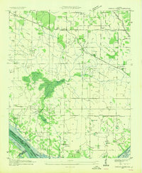
1954 Map of Sinking Creek
USGS Topo · Published 1954About this map
Sinking Creek winds through this Lauderdale County landscape, disappearing into subterranean drainage points like Ball Sink and Cunningham Sink. In the mid-1930s, the Tennessee Valley Authority was actively reshaping the southern edge of this region with the development of the Pickwick Landing Reservoir. The map documents the existing agrarian layout before the reservoir reached its full extent, showing established settlements such as Oakland and Rhodesville connected by a network of rural roads and early high-voltage transmission lines. Local life is anchored by numerous country churches and schools, including Galilee Ch, Shiloh Sch, and Ray Sch. Genealogy researchers will find significant value in the documentation of family-named burial grounds like Pearson Cem, Lipscomb Cem, and Vaughn Cem, which dot the uplands above the Harding Bottoms.
Find a feature on this map
64 named features on this map. Tap any name to fly to it.
Don’t see what you’re looking for? This feature index may not catch every label — zoom into the map to look around manually.
Map Details
Editions of this 1954 Sinking Creek Map
4 editions found
Other maps of this area

1914 · Muscle Shoals
USGS Topo · 1:48,000

1916 · Muscle Shoals
USGS Topo · 1:62,500

1924 · Tuscumbia
USGS Topo · 1:48,000

1924 · Gravelly Springs
USGS Topo · 1:48,000

1925 · Barton
USGS Topo · 1:62,500

1926 · Tuscumbia
USGS Topo · 1:62,500

1926 · Barton
USGS Topo · 1:48,000

1926 · Gravelly Springs
USGS Topo · 1:62,500

1929 · Barton
USGS Topo · 1:62,500

1935 · Cherokee
USGS Topo · 1:24,000