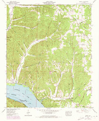
1953 Map of Wright
USGS Topo · Published 1973About this map
The Tennessee River and the backwaters of Pickwick Lake define the southern border of this Lauderdale County landscape. Settled pockets like Wright and Gravelly Springs sit at the base of a heavily dissected upland characterized by a dense network of timbered hollows, many carrying family names such as Spain Hollow, Gooch Hollow, and Landrum Hollow. The topography rises sharply from the riverbanks, where the Reservation Boundary marks federally managed lands along the shoreline.
Find a feature on this map
69 named features on this map. Tap any name to fly to it.
Don’t see what you’re looking for? This feature index may not catch every label — zoom into the map to look around manually.
Map Details
Editions of this 1953 Wright Map
3 editions found
Other maps of this area

1905 · Waynesboro
USGS Topo · 1:125,000

1911 · Iuka
USGS Topo · 1:48,000

1914 · Iuka
USGS Topo · 1:62,500

1924 · Gravelly Springs
USGS Topo · 1:48,000

1926 · Gravelly Springs
USGS Topo · 1:62,500

1935 · Cherokee
USGS Topo · 1:24,000

1935 · Wright
USGS Topo · 1:24,000

1936 · Margerum
USGS Topo · 1:24,000

1936 · Waterloo
USGS Topo · 1:24,000

1936 · Threet
USGS Topo · 1:24,000