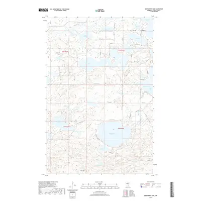
2019 Map of Siseebakwet Lake
USGS Topo · Published 2019About this map
Cohasset and the neighboring community of Bass Brook sit at the northern edge of this Minnesota landscape, where the Mississippi River winds through a complex system of glacial basins. The terrain is defined by its remarkable density of water bodies, including the sprawling Rice Lake, Loon Lake, and the distinctive Jay Gould Lake. To the south, the elevation rises toward the Sugar Hills, providing a physical backdrop to the clear waters of Siseebakwet Lake and Little Siseebakwet Lake. The map reveals a contemporary network of local connectors like Guile Lake Rd and N Sugar Lake Trl that provide access to the various bays and inlets, such as Sugar Bay and Salter Bay. This detailed documentation by the U.S. Geological Survey illustrates the modern configuration of Itasca County's lake-oriented residential and recreational geography, following the path of Sugar Brook through the woodlands.
Find a feature on this map
66 named features on this map. Tap any name to fly to it.
Don’t see what you’re looking for? This feature index may not catch every label — zoom into the map to look around manually.
Map Details
Editions of this 2019 Siseebakwet Lake Map
This is the sole edition of this map. No revisions or reprints were ever made.
Other maps of this area

1953 · Cohasset East
USGS Topo · 1:24,000

1953 · Siseebakwet Lake
USGS Topo · 1:24,000

1953 · Cohasset West
USGS Topo · 1:24,000

1953 · Grand Rapids
USGS Topo · 1:24,000

1954 · Hibbing
USGS Topo · 1:250,000

1957 · Hibbing
USGS Topo · 1:250,000

1958 · Hibbing
USGS Topo · 1:250,000

1964 · Hibbing
USGS Topo · 1:250,000

1970 · Big Thunder Peak
USGS Topo · 1:24,000
1970 · Mountain Ash Lake
USGS Topo · 1:24,000