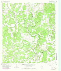
1964 Map of Sisterdale
USGS Topo · Published 1982About this map
Sisterdale serves as the focal point of this Hill Country landscape, situated at the confluence of several tributaries including East Sister Creek and West Sister Creek. The survey reveals a rural Texas economy transitioning into the mid-20th century, where traditional land use like a Cem and various Quarries exist alongside newer developments like the Landing Strip and Camp Alzafar. The meandering Guadalupe River carves a deep path through the center of the sheet, joined by many named drainages such as Wasp Creek and Jacobs Creek.
Find a feature on this map
28 named features on this map. Tap any name to fly to it.
Don’t see what you’re looking for? This feature index may not catch every label — zoom into the map to look around manually.
Map Details
Editions of this 1964 Sisterdale Map
2 editions found
Other maps of this area

1894 · Fredericksburg
USGS Topo · 1:125,000

1954 · Llano
USGS Topo · 1:250,000

1954 · San Antonio
USGS Topo · 1:250,000

1955 · Llano
USGS Topo · 1:250,000

1956 · Comfort
USGS Topo · 1:62,500

1956 · Llano
USGS Topo · 1:250,000

1957 · Boerne
USGS Topo · 1:62,500

1957 · San Antonio
USGS Topo · 1:250,000
1963 · Crabapple Creek
USGS Topo · 1:24,000

1963 · Whitworth Ranch
USGS Topo · 1:24,000