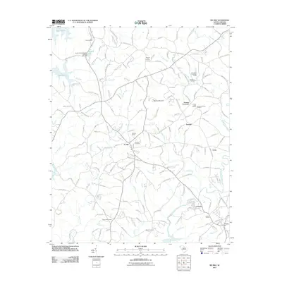
2011 Map of Six Mile
USGS Topo · Published 2011About this map
Six Mile serves as the central hub of this Pickens County landscape, situated amidst a complex network of waterways including Sixmile Creek and Twelvemile Creek. The topography is dominated by Sixmile Mountain and the expansive waters of Lake Keowee to the northwest. Local history is deeply embedded in the land through numerous family and community burial grounds, such as the Boroughs-Gillespie Cemetery and Norris Cemetery. Small communities like Cateechee and Norris anchor the southern portion of the sheet, while Terrapin Crossroads and Pearidge mark historical intersections to the east. The presence of Oakview Airport and the South Carolina Noname 39019 D-1971 Dam illustrates the modern infrastructure integrated into this traditionally rural area. This 2011 survey provides a clear view of the transition from the lakeside terrain to the established small towns and creek-side settlements that define the region's character.
Find a feature on this map
186 named features on this map. Tap any name to fly to it.
Don’t see what you’re looking for? This feature index may not catch every label — zoom into the map to look around manually.
Map Details
Editions of this 2011 Six Mile Map
This is the sole edition of this map. No revisions or reprints were ever made.
Other maps of this area

1888 · Pickens
USGS Topo · 1:125,000

1894 · Pickens
USGS Topo · 1:125,000

1951 · Clemson
USGS Topo · 1:24,000

1954 · Greenville
USGS Topo · 1:250,000

1957 · Anderson
USGS Topo · 1:62,500

1957 · Easley
USGS Topo · 1:62,500

1958 · Greenville
USGS Topo · 1:250,000

1958 · Seneca
USGS Topo · 1:24,000

1959 · Salem
USGS Topo · 1:24,000
1961 · Sunset
USGS Topo · 1:24,000