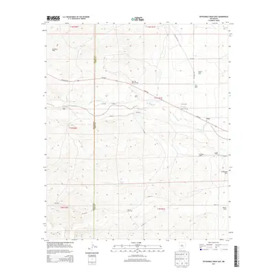
2013 Map of Sixteenmile Draw East
USGS Topo · Published 2013About this map
Rio Peñasco flows across the Chaves and Eddy County line, anchoring a landscape defined by ranching and the Hope Hwy corridor. Near the eastern edge of the survey, the community of Hope is situated near the Hope W Cem, serving as a central hub for the surrounding livestock operations. The map documents numerous established homesteads including the Anderson Young Ranch, Joe Young Ranch, and Hunter Ranch, highlighting the family names that have shaped this portion of the Pecos River basin. Arid watercourses like Charley White Draw, Catclaw Draw, and Sixteenmile Draw carve through the terrain, illustrating the drainage patterns that govern land use in this high-desert environment. Essential water infrastructure for cattle is noted at sites like the Walnut Ranch Well and Peñasco Well, providing critical evidence of pastoral survival in an area where permanent water is scarce.
Find a feature on this map
42 named features on this map. Tap any name to fly to it.
Don’t see what you’re looking for? This feature index may not catch every label — zoom into the map to look around manually.
Map Details
Editions of this 2013 Sixteenmile Draw East Map
This is the sole edition of this map. No revisions or reprints were ever made.
Other maps of this area

1954 · Carlsbad
USGS Topo · 1:250,000

1955 · Hope NW
USGS Topo · 1:24,000

1955 · Hope
USGS Topo · 1:24,000

1956 · Hope
USGS Topo · 1:24,000

1956 · Antelope Sink
USGS Topo · 1:24,000

1958 · Carlsbad
USGS Topo · 1:250,000

1960 · Teel Ranch
USGS Topo · 1:62,500

1978 · Encino Draw
USGS Topo · 1:24,000

1978 · Artesia
USGS Topo · 1:100,000
1978 · Holt Tank
USGS Topo · 1:24,000