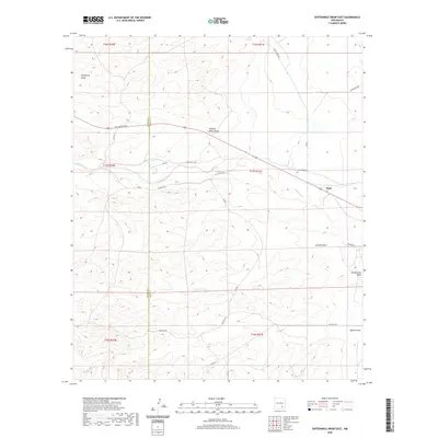
2020 Map of Sixteenmile Draw East
USGS Topo · Published 2020About this map
Rio Peñasco flows across this high desert landscape, carving a primary drainage route through the rugged draws of western New Mexico. In the eastern portion of the sheet, the village of Hope stands as a central settlement point, supported by local infrastructure like the Hope West Cem. The terrain is defined by a series of named ephemeral washes, including Charley White Draw, Catclaw Draw, and Sixteenmile Draw, which illustrate the complex natural irrigation patterns of the region. A network of rural routes, such as Low Valley Rd and Side Kick Rd, connects isolated ranching features like Sixteen Tank. The map also captures the boundary line between Chaves and Eddy Counties, providing a detailed look at land division in a region shaped by its arid climate and water management history.
Find a feature on this map
28 named features on this map. Tap any name to fly to it.
Don’t see what you’re looking for? This feature index may not catch every label — zoom into the map to look around manually.
Map Details
Editions of this 2020 Sixteenmile Draw East Map
This is the sole edition of this map. No revisions or reprints were ever made.
Other maps of this area

1954 · Carlsbad
USGS Topo · 1:250,000

1955 · Hope NW
USGS Topo · 1:24,000

1955 · Hope
USGS Topo · 1:24,000

1956 · Hope
USGS Topo · 1:24,000

1956 · Antelope Sink
USGS Topo · 1:24,000

1958 · Carlsbad
USGS Topo · 1:250,000

1960 · Teel Ranch
USGS Topo · 1:62,500

1978 · Encino Draw
USGS Topo · 1:24,000

1978 · Artesia
USGS Topo · 1:100,000
1978 · Holt Tank
USGS Topo · 1:24,000