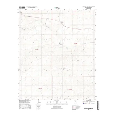
2017 Map of Sixteenmile Draw West
USGS Topo · Published 2017About this map
Rio Peñasco defines the hydrological character of this Chaves County landscape, winding through a complex system of arid drainage features. The terrain is marked by numerous named draws and canyons, including Sixteenmile Draw, Catclaw Draw, and the intersection of Cuevo Canyon with Little Cuevo Canyon. This 2017 survey illustrates the persistent importance of ranch roads and rural corridors in this part of New Mexico, showing how Rio Penasco Rd and Sagebrush Valley Rd navigate the undulating landforms. Water resources are scarce but specifically identified, such as Bluewater Cr and Singer Lake Draw, providing essential orientation for those studying the regional geography. The map clearly delineates the Public Land Survey System boundaries, including t17s r20e, which are vital for establishing contemporary and historical property locations.
Find a feature on this map
21 named features on this map. Tap any name to fly to it.
Don’t see what you’re looking for? This feature index may not catch every label — zoom into the map to look around manually.
Map Details
Editions of this 2017 Sixteenmile Draw West Map
This is the sole edition of this map. No revisions or reprints were ever made.
Other maps of this area

1954 · Carlsbad
USGS Topo · 1:250,000

1958 · Carlsbad
USGS Topo · 1:250,000

1960 · Teel Ranch
USGS Topo · 1:62,500

1962 · Dunken
USGS Topo · 1:62,500

1965 · Lewis Peak NE
USGS Topo · 1:24,000

1978 · Encino Draw
USGS Topo · 1:24,000

1978 · Artesia
USGS Topo · 1:100,000
1978 · Holt Tank
USGS Topo · 1:24,000

1979 · Alamogordo
USGS Topo · 1:100,000
1989 · Sixteenmile Draw West
USGS Topo · 1:24,000