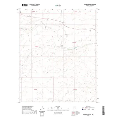
2023 Map of Sixteenmile Draw West
USGS Topo · Published 2023About this map
Rio Peñasco winds across this high desert landscape in Chaves County, defining a drainage network that includes Bluewater Creek and numerous deep draws. The terrain is characterized by a series of significant canyons and seasonal watercourses such as Little Cuevo Canyon, Singer Lake Draw, and Charley White Draw. These features suggest a topography of intermittent flow and erosion, critical for understanding the historic land use and movement through this part of New Mexico.
Find a feature on this map
22 named features on this map. Tap any name to fly to it.
Don’t see what you’re looking for? This feature index may not catch every label — zoom into the map to look around manually.
Map Details
Editions of this 2023 Sixteenmile Draw West Map
This is the sole edition of this map. No revisions or reprints were ever made.
Other maps of this area

1954 · Carlsbad
USGS Topo · 1:250,000

1958 · Carlsbad
USGS Topo · 1:250,000

1960 · Teel Ranch
USGS Topo · 1:62,500

1962 · Dunken
USGS Topo · 1:62,500

1965 · Lewis Peak NE
USGS Topo · 1:24,000

1978 · Encino Draw
USGS Topo · 1:24,000

1978 · Artesia
USGS Topo · 1:100,000
1978 · Holt Tank
USGS Topo · 1:24,000

1979 · Alamogordo
USGS Topo · 1:100,000
1989 · Sixteenmile Draw West
USGS Topo · 1:24,000