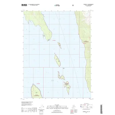
2017 Map of Skagway A-1 SW
USGS Topo · Published 2017About this map
Sullivan Island and a chain of smaller landmasses dominate this coastal survey where the waters of the Gulf of Alaska reach deep into the interior. Positioned within the southern reaches of the Tongass National Forest, the map captures the meeting of the Chilkat Inlet and Chilkoot Inlet at the mouth of Lynn Canal. This maritime environment is defined by distinctive nautical landmarks such as Seduction Point and a series of smaller islands including Shikosi Island, Kataguni Island, and Talsani Island. The rugged coastline features localized points of interest like Katlangu Cove and the drainage of Yeldagalga Cr, illustrating the complex geography of the Alaskan Panhandle. While primarily a wilderness of water and forest, the map provides precise boundary markers for townships such as t32s r60e, outlining the administrative framework of this maritime landscape.
Find a feature on this map
20 named features on this map. Tap any name to fly to it.
Don’t see what you’re looking for? This feature index may not catch every label — zoom into the map to look around manually.
Map Details
Editions of this 2017 Skagway A-1 SW Map
This is the sole edition of this map. No revisions or reprints were ever made.
Other maps of this area

1948 · Skagway A-1
USGS Topo · 1:63,360

1949 · Juneau D-5
USGS Topo · 1:63,360

1949 · Juneau D-4
USGS Topo · 1:63,360

1951 · Juneau
USGS Topo · 1:250,000

1951 · Skagway A-1
USGS Topo · 1:63,360

1951 · Juneau D-4
USGS Topo · 1:63,360

1952 · Skagway
USGS Topo · 1:250,000

1954 · Skagway A-2
USGS Topo · 1:63,360

1961 · Skagway
USGS Topo · 1:250,000

1962 · Juneau
USGS Topo · 1:250,000