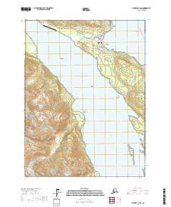
2017 Map of Skagway A-2 NE
USGS Topo · Published 2017About this map
The coastal town of Haines serves as the focal point of this 2017 survey, situated prominently on the northern end of the Chilkat Peninsula. The map illustrates the narrow Deshu Isthmus that separates Portage Cove and the Chilkoot Inlet from the expansive Chilkat Inlet to the west. Local infrastructure is well-defined, featuring the Haines Airport and a detailed street network including the Haines Highway and Front Street.
Find a feature on this map
66 named features on this map. Tap any name to fly to it.
Don’t see what you’re looking for? This feature index may not catch every label — zoom into the map to look around manually.
Map Details
Editions of this 2017 Skagway A-2 NE Map
This is the sole edition of this map. No revisions or reprints were ever made.
Other maps of this area

1948 · Skagway A-1
USGS Topo · 1:63,360

1949 · Skagway B-1
USGS Topo · 1:63,360

1951 · Skagway A-1
USGS Topo · 1:63,360

1951 · Skagway B-1
USGS Topo · 1:63,360

1952 · Skagway
USGS Topo · 1:250,000

1954 · Skagway B-2
USGS Topo · 1:63,360

1954 · Skagway A-2
USGS Topo · 1:63,360

1961 · Skagway
USGS Topo · 1:250,000
1991 · Skagway B-2 SW
USGS Topo · 1:25,000
1991 · Skagway A-1 NW
USGS Topo · 1:25,000