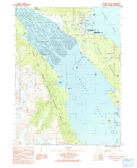
1991 Map of Skagway A-2 NE
USGS Topo · Published 1991About this map
Haines stands as the primary hub of this maritime landscape, situated where the Deshu Isthmus connects the Chilkat Peninsula to the mainland. The area's military and transport history is prominent, featuring the historic Fort William H Seward and the inland reach of the Haines Highway. To the west, the Dalton Trail marks an older path through the terrain near the Mc Clellan Flats and the Chilkat River.
Find a feature on this map
51 named features on this map. Tap any name to fly to it.
Don’t see what you’re looking for? This feature index may not catch every label — zoom into the map to look around manually.
Map Details
Editions of this 1991 Skagway A-2 NE Map
This is the sole edition of this map. No revisions or reprints were ever made.
Other maps of this area

1948 · Skagway A-1
USGS Topo · 1:63,360

1949 · Skagway B-1
USGS Topo · 1:63,360

1951 · Skagway A-1
USGS Topo · 1:63,360

1951 · Skagway B-1
USGS Topo · 1:63,360

1952 · Skagway
USGS Topo · 1:250,000

1954 · Skagway B-2
USGS Topo · 1:63,360

1954 · Skagway A-2
USGS Topo · 1:63,360

1961 · Skagway
USGS Topo · 1:250,000
1991 · Skagway B-2 SW
USGS Topo · 1:25,000
1991 · Skagway A-1 NW
USGS Topo · 1:25,000