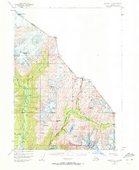
1948 Map of Skagway C-1
USGS Topo · Published 1972About this map
The White Pass and Yukon Route snakes through this high mountain pass landscape, tracing the vital transit artery between Alaska and British Columbia established during the gold rush era. This 1948 survey documents the challenging terrain of the Tongass National Forest where the industrial and natural worlds intersect at sites like Clifton and the Inspiration Mine. The map details the legacy of northern passage at Chilkoot Pass and White Pass, illustrating how surveyors and engineers negotiated the steep drainage of the Taiya River and Nourse River. Small-scale industrial markers like Hasfords Sawmill and the 8 Mile Canyon Prospect appear alongside massive natural features such as the Laughton Glacier and Saussure Glacier, providing a window into the remote extraction and transportation networks that defined the region’s mid-century development.
Find a feature on this map
34 named features on this map. Tap any name to fly to it.
Don’t see what you’re looking for? This feature index may not catch every label — zoom into the map to look around manually.
Map Details
Editions of this 1948 Skagway C-1 Map
2 editions found
Other maps of this area

1948 · Skagway C-2
USGS Topo · 1:63,360

1948 · Skagway C-1
USGS Topo · 1:63,360

1949 · Atlin
USGS Topo · 1:250,000

1949 · Skagway B-1
USGS Topo · 1:63,360
1949 · Skagway D-2
USGS Topo · 1:63,360

1951 · Skagway C-1
USGS Topo · 1:63,360

1951 · Atlin
USGS Topo · 1:250,000

1951 · Skagway B-1
USGS Topo · 1:63,360

1951 · Skagway C-2
USGS Topo · 1:63,360

1952 · Skagway
USGS Topo · 1:250,000