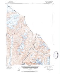
1951 Map of Skagway C-1
USGS Topo · Published 1952About this map
The White Pass and Yukon Route snakes through the narrow mountain corridors of the Coast Range in this mid-century survey. This map documents the critical transit points between Alaska and British Columbia, including the storied Chilkoot Pass and White Pass, which served as the primary gateways for prospectors decades earlier. The small settlement at Clifton sits along the rail line, positioned where the terrain transitions from the tidal influence of the Taiya River to the steep glacial valleys of the interior.
Find a feature on this map
25 named features on this map. Tap any name to fly to it.
Don’t see what you’re looking for? This feature index may not catch every label — zoom into the map to look around manually.
Map Details
Editions of this 1951 Skagway C-1 Map
2 editions found
Other maps of this area

1948 · Skagway C-2
USGS Topo · 1:63,360

1948 · Skagway C-1
USGS Topo · 1:63,360

1949 · Atlin
USGS Topo · 1:250,000

1949 · Skagway B-1
USGS Topo · 1:63,360
1949 · Skagway D-2
USGS Topo · 1:63,360

1951 · Skagway C-1
USGS Topo · 1:63,360

1951 · Atlin
USGS Topo · 1:250,000

1951 · Skagway B-1
USGS Topo · 1:63,360

1951 · Skagway C-2
USGS Topo · 1:63,360

1952 · Skagway
USGS Topo · 1:250,000