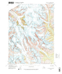
1948 Map of Skagway C-2
USGS Topo · Published 1975About this map
The boundary between the United States and Canada defines the high-altitude landscape shown on this topographic survey, marking the jagged transition between Alaska and British Columbia. At the center of this glacial complex, the Chilkat Glacier and Ferebee Glacier dominate the terrain, carving deep valleys through the coastal range. These massive ice fields represent the primary geological force in the region, feeding the headwaters of the Nourse River to the east. The map provides a precise look at the 1948 extent of these glaciers, including Irene Glacier and the prominent peak of Mt Yeatman, offering an essential record of the cryosphere before late 20th-century shifts. Administratively, the area falls within the Haines Borough, highlighting the administrative reach into these high-alpine environments.
Find a feature on this map
8 named features on this map. Tap any name to fly to it.
Don’t see what you’re looking for? This feature index may not catch every label — zoom into the map to look around manually.
Map Details
Editions of this 1948 Skagway C-2 Map
3 editions found
Other maps of this area

1948 · Skagway C-3
USGS Topo · 1:63,360

1948 · Skagway C-2
USGS Topo · 1:63,360

1948 · Skagway C-1
USGS Topo · 1:63,360

1949 · Skagway B-1
USGS Topo · 1:63,360
1949 · Skagway D-2
USGS Topo · 1:63,360

1951 · Skagway C-1
USGS Topo · 1:63,360

1951 · Skagway B-1
USGS Topo · 1:63,360

1951 · Skagway C-2
USGS Topo · 1:63,360

1952 · Skagway
USGS Topo · 1:250,000

1954 · Skagway B-2
USGS Topo · 1:63,360