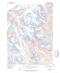
1951 Map of Skagway C-2
USGS Topo · Published 1952About this map
Ice and rock define this mid-century survey of the Coast Range along the international boundary between Alaska and British Columbia. The map documents the immense scale of the Chilkat Glacier and the Ferebee Glacier as they flowed through the high elevations during the late 1940s. These massive ice fields, alongside the Irene Glacier, dominate the topography, revealing a landscape where glacial movement is the primary architect of the terrain. The presence of Mt Yeatman and the headwaters of the Nourse River provide critical geographic markers for understanding the drainage patterns and mountain structure of the United States-Canada border region in the years following the Second World War.
Find a feature on this map
10 named features on this map. Tap any name to fly to it.
Don’t see what you’re looking for? This feature index may not catch every label — zoom into the map to look around manually.
Map Details
Editions of this 1951 Skagway C-2 Map
2 editions found
Other maps of this area

1948 · Skagway C-3
USGS Topo · 1:63,360

1948 · Skagway C-2
USGS Topo · 1:63,360

1948 · Skagway C-1
USGS Topo · 1:63,360

1949 · Skagway B-1
USGS Topo · 1:63,360
1949 · Skagway D-2
USGS Topo · 1:63,360

1951 · Skagway C-1
USGS Topo · 1:63,360

1951 · Skagway B-1
USGS Topo · 1:63,360

1951 · Skagway C-2
USGS Topo · 1:63,360

1952 · Skagway
USGS Topo · 1:250,000

1954 · Skagway B-2
USGS Topo · 1:63,360