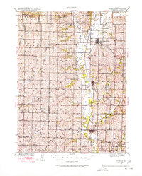
1939 Map of Skidmore
USGS Topo · Published 1980About this map
The Nodaway River valley in Northwest Missouri is defined here by its dense network of rural one-room schoolhouses and the Chicago Burlington and Quincy railroad line connecting the river towns. In the late 1930s, this agrarian landscape was meticulously organized into townships like Lincoln, Greene, and Monroe, with each section supported by its own local school, such as Hedge College Sch, Little Brick Sch, or Possum Walk Sch.
Find a feature on this map
58 named features on this map. Tap any name to fly to it.
Don’t see what you’re looking for? This feature index may not catch every label — zoom into the map to look around manually.
Map Details
Editions of this 1939 Skidmore Map
3 editions found
Other maps of this area

1920 · Craig
USGS Topo · 1:62,500

1926 · Maitland
USGS Topo · 1:62,500

1927 · Bolckow
USGS Topo · 1:62,500

1939 · Tarkio
USGS Topo · 1:62,500

1939 · Farragut
USGS Topo · 1:62,500

1939 · Skidmore
USGS Topo · 1:62,500

1940 · Tarkio
USGS Topo · 1:62,500

1940 · Farragut
USGS Topo · 1:62,500

1940 · Coin
USGS Topo · 1:62,500

1940 · New Market
USGS Topo · 1:62,500