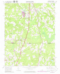
1963 Map of Skippers
USGS Topo · Published 1980About this map
Skippers sits at a critical junction of the Seaboard Coast Line and the interstate corridor, serving as a gateway between Virginia and North Carolina during the early 1960s. The landscape is defined by the winding course of Fontaine Creek, which anchors a network of smaller drainages including Cattail Creek and Beaverpond Creek. These waterways once powered local industry, evidenced by landmarks such as Mitchells Mill and Corwells Millpond.
Find a feature on this map
34 named features on this map. Tap any name to fly to it.
Don’t see what you’re looking for? This feature index may not catch every label — zoom into the map to look around manually.
Map Details
Editions of this 1963 Skippers Map
Other maps of this area

1919 · Emporia
USGS Topo · 1:62,500

1919 · Arringdale
USGS Topo · 1:48,000

1920 · Arringdale
USGS Topo · 1:62,500

1942 · Arringdale
USGS Topo · 1:62,500

1942 · Emporia
USGS Topo · 1:62,500

1953 · Norfolk
USGS Topo · 1:250,000

1963 · Skippers
USGS Topo · 1:24,000

1963 · Barley
USGS Topo · 1:24,000

1963 · Emporia
USGS Topo · 1:24,000

1963 · Ante
USGS Topo · 1:24,000