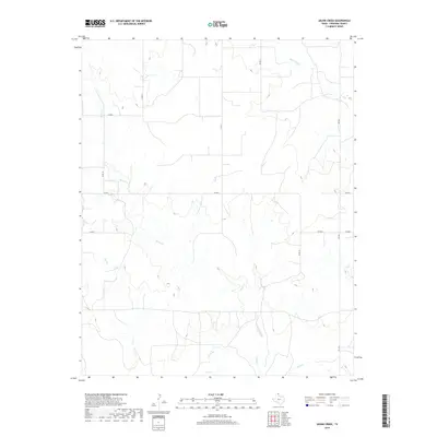
2019 Map of Skunk Creek
USGS Topo · Published 2019About this map
Skunk Creek winds through the northern panhandle landscape of Lipscomb County, defining the drainage patterns of this rural ranching and agricultural region. In the late 2010s, this area remains characterized by a sparse network of county roads such as Co RD 21 and Co RD N, reflecting the large-scale landholdings common to the High Plains. The southern portion of the map is anchored by the flow of Wolf Cr, while smaller tributaries like Cat Cr and Mammoth Cr etch subtle relief into the terrain. State-maintained routes FM 1454 and FM 3004 provide the primary transit corridors through this open country, where the intersection of water resources and transportation infrastructure continues to dictate the local land use.
Find a feature on this map
14 named features on this map. Tap any name to fly to it.
Don’t see what you’re looking for? This feature index may not catch every label — zoom into the map to look around manually.
Map Details
Editions of this 2019 Skunk Creek Map
This is the sole edition of this map. No revisions or reprints were ever made.
Other maps of this area

1954 · Perryton
USGS Topo · 1:250,000

1958 · Perryton
USGS Topo · 1:250,000

1972 · Follett SE
USGS Topo · 1:24,000

1972 · Dugout Creek
USGS Topo · 1:24,000

1972 · Skunk Creek
USGS Topo · 1:24,000
1972 · Magoun
USGS Topo · 1:24,000

1972 · Follett
USGS Topo · 1:24,000
1972 · Higgins North
USGS Topo · 1:24,000

1972 · Willow Creek
USGS Topo · 1:24,000

1972 · Lipscomb
USGS Topo · 1:24,000