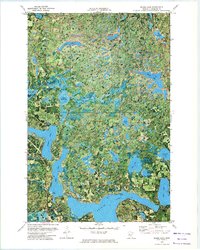
1972 Map of Skunk Lake
USGS Topo · Published 1974About this map
Potato Lake anchors the southern expanse of this Hubbard County terrain, surrounded by a dense network of glacial basins and interconnected waterways. The township boundaries of Clover, Arago, and Emma divide a landscape defined by its varied water bodies, ranging from the elongated Island Lake to the scattered clusters of Many Arm Lake and Churchill Lake. The orthophotomap format provides a unique view of the 1970s vegetation and shoreline patterns, highlighting the transition between open water and the surrounding timberland. Human activity is visible through the designated Public Access points along the larger lakes and a Gravel Pit located near the eastern shore of Eagle Lake, indicating the local resource extraction and recreational footprint during this era. This 1972 survey, based on 1969 aerial photography, documents the intricate hydrography of the region before significant modern development altered these shores.
Find a feature on this map
28 named features on this map. Tap any name to fly to it.
Don’t see what you’re looking for? This feature index may not catch every label — zoom into the map to look around manually.
Map Details
Editions of this 1972 Skunk Lake Map
This is the sole edition of this map. No revisions or reprints were ever made.
Other maps of this area

1953 · Brainerd
USGS Topo · 1:250,000

1954 · Bemidji
USGS Topo · 1:250,000

1957 · Brainerd
USGS Topo · 1:250,000

1957 · Bemidji
USGS Topo · 1:250,000

1958 · Bemidji
USGS Topo · 1:250,000

1958 · Brainerd
USGS Topo · 1:250,000

1965 · Brainerd
USGS Topo · 1:250,000

1969 · Park Rapids
USGS Topo · 1:24,000
1969 · Park Rapids NW
USGS Topo · 1:24,000

1970 · Dorset
USGS Topo · 1:24,000