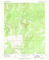
1966 Map of Skutumpah Creek
USGS Topo · Published 1968About this map
Skutumpah Creek and its complex network of seasonal drainages define this mid-1960s landscape in Kane County. The terrain is characterized by dramatic elevation shifts across the Skutumpah Terrace and the jagged erosional features of the Red Breaks. Evidence of early cattle ranching and movement through the backcountry is preserved through the naming of the Old Corral Trail and numerous water sources like First Point Spring and Cottonwood Spring. This era shows a landscape primarily utilized for grazing and transit, with little permanent infrastructure beyond established jeep trails. Distinctive landmarks such as Table Mountain and Carly Knoll served as essential navigational markers for those moving between Mill Creek and Johnson Canyon. The map reveals a high-desert environment where topographic names like Coal Canyon and Mineral Creek suggest the underlying geology that shaped local land use and exploration.
Find a feature on this map
35 named features on this map. Tap any name to fly to it.
Don’t see what you’re looking for? This feature index may not catch every label — zoom into the map to look around manually.
Map Details
Editions of this 1966 Skutumpah Creek Map
2 editions found
Other maps of this area

1886 · Kanab
USGS Topo · 1:250,000

1953 · Cedar City
USGS Topo · 1:250,000

1954 · Buckskin Gulch NW
USGS Topo · 1:24,000

1954 · Johnson NE
USGS Topo · 1:24,000

1954 · Buckskin Gulch
USGS Topo · 1:62,500

1954 · Johnson
USGS Topo · 1:62,500

1958 · Cedar City
USGS Topo · 1:250,000

1962 · Cedar City
USGS Topo · 1:250,000

1966 · Alton
USGS Topo · 1:24,000

1966 · Bald Knoll
USGS Topo · 1:24,000