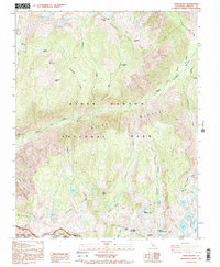
1992 Map of Slide Bluffs
USGS Topo · Published 1994About this map
Middle Fork Kings River carves through the center of this high Sierra landscape, creating a dramatic vertical relief defined by the massive Slide Bluffs and the Gorge of Despair. Published in the early 1990s from 1984 photography, this survey details the intersection of Kings Canyon National Park and the Monarch Wilderness. High-altitude basins like those containing the Volcanic Lakes and Swamp Lakes are separated by the formidable White Divide and Monarch Divide. The map illustrates a wilderness economy of trail-based travel, marking remote points of interest such as Simpson Meadow and Bunchgrass Flat. Notable peaks including Tunemah Peak and Kennedy Mountain provide orientation for those studying the drainage patterns of Goddard Creek and Alpine Creek as they descend toward the river valley.
Find a feature on this map
45 named features on this map. Tap any name to fly to it.
Don’t see what you’re looking for? This feature index may not catch every label — zoom into the map to look around manually.
Map Details
Editions of this 1992 Slide Bluffs Map
2 editions found
Other maps of this area

1903 · Tehipite
USGS Topo · 1:125,000

1905 · Tehipite
USGS Topo · 1:125,000

1912 · Mt. Goddard
USGS Topo · 1:125,000

1947 · Mariposa
USGS Topo · 1:250,000

1948 · Fresno
USGS Topo · 1:250,000

1948 · Mariposa
USGS Topo · 1:250,000

1948 · Mt. Goddard
USGS Topo · 1:62,500

1951 · Mt. Goddard
USGS Topo · 1:62,500

1952 · Mt. Goddard
USGS Topo · 1:62,500

1952 · Tehipite Dome
USGS Topo · 1:62,500