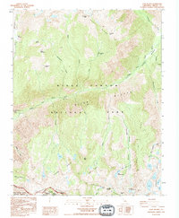
1992 Map of Slide Bluffs
USGS Topo · Published 1994About this map
Kings Canyon National Park dominates this high-altitude landscape in Fresno County, where the Middle Fork Kings River carves through the massive granite formations of the Slide Bluffs. This 1992 photo-inspection reveals a wilderness shaped by extreme vertical relief, stretching from the White Divide in the north to the Monarch Divide at the southern boundary. The topography is defined by sharp glacial features, including the aptly named Gorge of Despair and high alpine basins containing the Swamp Lakes and Volcanic Lakes. Evidence of seasonal grazing and early mountain travel is preserved in labels like Lightning Corral and Gravel Meadow. The map meticulously tracks the drainages of Blue Canyon, which drops over Blue Canyon Falls, and the complex network of creeks such as Alpine Creek and Dog Creek that feed the river system below Tunemah Peak.
Find a feature on this map
44 named features on this map. Tap any name to fly to it.
Don’t see what you’re looking for? This feature index may not catch every label — zoom into the map to look around manually.
Map Details
Editions of this 1992 Slide Bluffs Map
2 editions found
Other maps of this area

1903 · Tehipite
USGS Topo · 1:125,000

1905 · Tehipite
USGS Topo · 1:125,000

1912 · Mt. Goddard
USGS Topo · 1:125,000

1947 · Mariposa
USGS Topo · 1:250,000

1948 · Fresno
USGS Topo · 1:250,000

1948 · Mariposa
USGS Topo · 1:250,000

1948 · Mt. Goddard
USGS Topo · 1:62,500

1951 · Mt. Goddard
USGS Topo · 1:62,500

1952 · Mt. Goddard
USGS Topo · 1:62,500

1952 · Tehipite Dome
USGS Topo · 1:62,500