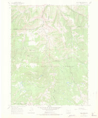
1966 Map of Slide Creek
USGS Topo · Published 1969About this map
The high-country divide of the Rocky Mountains is defined here by the intersection of three counties—Moffat, Routt, and Rio Blanco—during the mid-1960s. The landscape is dominated by the massive terrain of Big Sugarloaf Mountain and Upper Sugarloaf Mountain, with the hydrological network draining into the Williams Fork and the South Fork Williams Fork. This area, managed between the White River National Forest and Routt National Forest, shows a wilderness infrastructure of remote landmarks like Scott Hill and the small clearing at Salt Park.
Find a feature on this map
29 named features on this map. Tap any name to fly to it.
Don’t see what you’re looking for? This feature index may not catch every label — zoom into the map to look around manually.
Map Details
Editions of this 1966 Slide Creek Map
4 editions found
Other maps of this area

1910 · Danforth Hills
USGS Topo · 1:125,000

1915 · Monument Butte
USGS Topo · 1:62,500

1916 · Daton Peak
USGS Topo · 1:62,500

1920 · Daton Peak
USGS Topo · 1:62,500

1954 · Craig
USGS Topo · 1:250,000

1957 · Craig
USGS Topo · 1:250,000

1958 · Craig
USGS Topo · 1:250,000

1960 · Craig
USGS Topo · 1:250,000

1962 · Craig
USGS Topo · 1:250,000

1964 · Craig
USGS Topo · 1:250,000