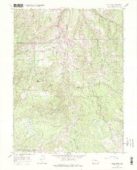
1966 Map of Slide Creek
USGS Topo · Published 1975About this map
White River National Forest and Routt National Forest converge in this high-elevation landscape, where the tri-county boundary of Moffat, Rio Blanco, and Routt counties meets. The drainage system is anchored by the South Fork Williams Fork, which is fed by numerous tributaries including Pagoda Creek, Berry Creek, and Slide Creek. A notable piece of water infrastructure, the Sullivan Ditch, cuts across the northern slopes, while the South Fork Trail provides the primary human access point through the mountain passes.
Find a feature on this map
28 named features on this map. Tap any name to fly to it.
Don’t see what you’re looking for? This feature index may not catch every label — zoom into the map to look around manually.
Map Details
Editions of this 1966 Slide Creek Map
4 editions found
Other maps of this area

1910 · Danforth Hills
USGS Topo · 1:125,000

1915 · Monument Butte
USGS Topo · 1:62,500

1916 · Daton Peak
USGS Topo · 1:62,500

1920 · Daton Peak
USGS Topo · 1:62,500

1954 · Craig
USGS Topo · 1:250,000

1957 · Craig
USGS Topo · 1:250,000

1958 · Craig
USGS Topo · 1:250,000

1960 · Craig
USGS Topo · 1:250,000

1962 · Craig
USGS Topo · 1:250,000

1964 · Craig
USGS Topo · 1:250,000