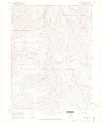
1966 Map of Slide Creek
USGS Topo · Published 1969About this map
White River National Forest and Routt National Forest coverage dominates this mid-1960s survey of the high-altitude landscape where Moffat, Routt, and Rio Blanco counties converge. The terrain is defined by dramatic peaks and drainage networks, with Big Sugarloaf Mountain and Horse Mountain rising above the headwaters of numerous creeks. A notable hydrological feature is the Sullivan Ditch, which redirects water across the mountain slopes, while a Gaging Sta monitors the flow along the South Fork Williams Fork. In the southern reaches of the quadrangle, high meadows like Salt Park and Lost Park provide a break in the timbered slopes. The presence of the Corral Creek Trail and various unimproved dirt roads suggests the area's primary uses for forestry, watershed management, and high-country recreation during this era.
Find a feature on this map
28 named features on this map. Tap any name to fly to it.
Don’t see what you’re looking for? This feature index may not catch every label — zoom into the map to look around manually.
Map Details
Editions of this 1966 Slide Creek Map
4 editions found
Other maps of this area

1910 · Danforth Hills
USGS Topo · 1:125,000

1915 · Monument Butte
USGS Topo · 1:62,500

1916 · Daton Peak
USGS Topo · 1:62,500

1920 · Daton Peak
USGS Topo · 1:62,500

1954 · Craig
USGS Topo · 1:250,000

1957 · Craig
USGS Topo · 1:250,000

1958 · Craig
USGS Topo · 1:250,000

1960 · Craig
USGS Topo · 1:250,000

1962 · Craig
USGS Topo · 1:250,000

1964 · Craig
USGS Topo · 1:250,000