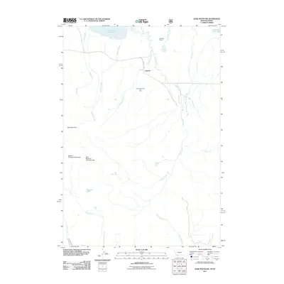
2011 Map of Slide Mountain
USGS Topo · Published 2011About this map
Lakeview serves as the primary settlement hub in this high-altitude basin, positioned along the Southside Centennial Rd and supported by the Lakeview Airport. The landscape is defined by the hydrologic transition from the peaks of the Western Centennial Mountains down to the sprawling marshlands of the Centennial Valley. Important water bodies including Lower Red Rock Lake and Upper Red Rock Lake dominate the northern drainage, fed by a complex network of seasonal and perennial streams like Duff Creek, Odell Creek, and Shambow Creek. Recreational development is evident at the Lakeview Mountain Ski Area, situated on the slopes north of the mountain divide. Further south, the terrain rises sharply toward Baldy Mountain and Slide Mountain, where remote high-country features such as Hancock Lake sit in the shadow of the continental divide, marking a transition into the more secluded reaches of the Montana-Idaho border region.
Find a feature on this map
21 named features on this map. Tap any name to fly to it.
Don’t see what you’re looking for? This feature index may not catch every label — zoom into the map to look around manually.
Map Details
Editions of this 2011 Slide Mountain Map
This is the sole edition of this map. No revisions or reprints were ever made.
Other maps of this area

1950 · Lower Red Rock Lake
USGS Topo · 1:62,500

1950 · Upper Red Rock Lake
USGS Topo · 1:62,500

1955 · Ashton
USGS Topo · 1:250,000

1958 · Ashton
USGS Topo · 1:250,000

1960 · Ashton
USGS Topo · 1:250,000

1965 · Sheridan Reservoir
USGS Topo · 1:24,000

1972 · Antelope Valley
USGS Topo · 1:24,000

1972 · Kilgore
USGS Topo · 1:24,000
1988 · Lower Red Rock Lake
USGS Topo · 1:24,000
1988 · Upper Red Rock Lake
USGS Topo · 1:24,000