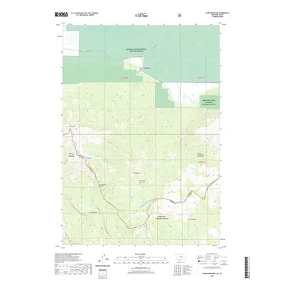
2020 Map of Slide Mountain
USGS Topo · Published 2020About this map
Lakeview sits on the edge of the Red Rock Lakes National Wildlife Refuge, a landscape where the valley floor meets the high peaks of the Centennial Mountains. This high-altitude terrain is defined by the Continental Divide, which separates Beaverhead County, Montana, and Clark County, Idaho. The area is characterized by significant hydrological features including Lower Red Rock Lake and several mountain lakes such as Aldous Lake, Hancock Lake, and Walking Fish Lake.
Find a feature on this map
38 named features on this map. Tap any name to fly to it.
Don’t see what you’re looking for? This feature index may not catch every label — zoom into the map to look around manually.
Map Details
Editions of this 2020 Slide Mountain Map
This is the sole edition of this map. No revisions or reprints were ever made.
Other maps of this area

1950 · Lower Red Rock Lake
USGS Topo · 1:62,500

1950 · Upper Red Rock Lake
USGS Topo · 1:62,500

1955 · Ashton
USGS Topo · 1:250,000

1958 · Ashton
USGS Topo · 1:250,000

1960 · Ashton
USGS Topo · 1:250,000

1965 · Sheridan Reservoir
USGS Topo · 1:24,000

1972 · Antelope Valley
USGS Topo · 1:24,000

1972 · Kilgore
USGS Topo · 1:24,000
1988 · Lower Red Rock Lake
USGS Topo · 1:24,000
1988 · Upper Red Rock Lake
USGS Topo · 1:24,000