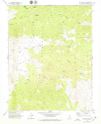
1969 Map of Slidy Mountain
USGS Topo · Published 1979About this map
The Delamar Mountains dominate this high-desert landscape in Lincoln County, where complex drainage systems and isolated peaks define the terrain. Rising over the surrounding area, Slidy Mountain and Applewhite Summit overlook a network of ephemeral watercourses including Kane Springs Wash and Narrow Canyon. The human presence is primarily marked by historical extraction and water management, evidenced by several scattered Mines and multiple Prospects throughout the ridges. Water sources were critical for survival and industry in this arid environment, recorded here through named points like Bishop Spring, Tunnel Spring, and the high-elevation Blyth Spring. The map identifies the Finlay (Site), suggesting a former human habitation or camp that has since passed into the archaeological record. A web of Jeep Trails provides the only access through the rugged washes, connecting these remote springs and mine sites across the mountain range.
Find a feature on this map
30 named features on this map. Tap any name to fly to it.
Don’t see what you’re looking for? This feature index may not catch every label — zoom into the map to look around manually.
Map Details
Editions of this 1969 Slidy Mountain Map
2 editions found
Other maps of this area

1885 · Pioche
USGS Topo · 1:250,000

1886 · Pioche
USGS Topo · 1:250,000

1954 · Caliente
USGS Topo · 1:250,000

1959 · Caliente
USGS Topo · 1:250,000

1969 · Delamar
USGS Topo · 1:24,000

1969 · Gregerson Basin
USGS Topo · 1:24,000

1969 · Elgin
USGS Topo · 1:24,000

1969 · Elgin NE
USGS Topo · 1:24,000

1969 · Slidy Mountain
USGS Topo · 1:24,000

1969 · Elgin SW
USGS Topo · 1:24,000