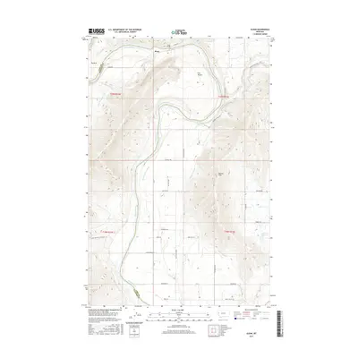
2017 Map of Sloan
USGS Topo · Published 2017About this map
The Sloan settlement and the Sloan Bridge serve as focal points along the meandering Flathead River as it winds through northwestern Montana. This area is defined by the significant hydraulic engineering of the Moiese valley, where the Moiese A Canal and Hillside Ditch facilitate irrigation across the landscape south of the Moiese Hills. The river itself creates dramatic geographic features including the Big Bend and The Oxbow, illustrating the natural hydrological evolution of the region. Local travel is marked by a network of rural routes such as Sloan Rd, Moiese Valley Rd, and Schoolhouse Ln, which connect agricultural homesteads and remote water features like the Hillside Reservoir. The map also captures the confluence where the Little Bitterroot River meets the larger drainage system, highlighting the area's importance as a watershed.
Find a feature on this map
33 named features on this map. Tap any name to fly to it.
Don’t see what you’re looking for? This feature index may not catch every label — zoom into the map to look around manually.
Map Details
Editions of this 2017 Sloan Map
This is the sole edition of this map. No revisions or reprints were ever made.
Other maps of this area

1920 · Flathead Lake
USGS Topo · 1:125,000

1956 · Wallace
USGS Topo · 1:250,000

1960 · Wallace
USGS Topo · 1:250,000

1964 · Dixon
USGS Topo · 1:24,000

1964 · Mc Donald
USGS Topo · 1:24,000

1964 · Melton Ranch
USGS Topo · 1:24,000

1964 · Lower Crow Reservoir
USGS Topo · 1:24,000

1964 · Ravalli
USGS Topo · 1:24,000

1965 · Sloan
USGS Topo · 1:24,000

1965 · Oliver Point
USGS Topo · 1:24,000