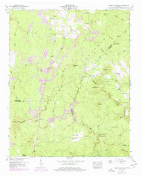
1946 Map of Smartt Mountain
USGS Topo · Published 1977About this map
The high Cumberland Plateau terrain of Van Buren, Bledsoe, and Sequatchie Counties is the primary focus of this mid-century survey. The landscape is defined by its industrial and rural character, where numerous Strip Mine operations mark the ridges and hollows near Smartt Mtn and Hills Mtn. Settlement is scattered, with local community life anchored by the Bellview Ch and family burying grounds such as Walling Cem and Miller Cem.
Find a feature on this map
55 named features on this map. Tap any name to fly to it.
Don’t see what you’re looking for? This feature index may not catch every label — zoom into the map to look around manually.
Map Details
Editions of this 1946 Smartt Mountain Map
4 editions found
Other maps of this area

1888 · Chattanooga
USGS Topo · 1:125,000

1892 · Pikeville
USGS Topo · 1:125,000

1893 · Mc Minnville
USGS Topo · 1:125,000

1893 · Chattanooga
USGS Topo · 1:125,000

1895 · Mc Minnville
USGS Topo · 1:125,000

1895 · Sewanee
USGS Topo · 1:125,000

1895 · Pikeville
USGS Topo · 1:125,000

1935 · Brockdell
USGS Topo · 1:24,000

1935 · Mount Airy
USGS Topo · 1:24,000

1935 · Smart Mountain
USGS Topo · 1:24,000