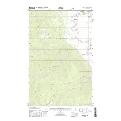
2017 Map of Smith Falls
USGS Topo · Published 2017About this map
The Kootenai River winds through the Purcell Trench just south of the United States of America/Canada border, marking a landscape of significant elevation changes and hydroelectric potential. Within the Kaniksu National Forest, the terrain rises sharply from the river valley to prominent summits like Italian Peak and Eneas Peak. A network of backcountry routes, including the Pacific NW National Scenic Trail and the Canyon Creek NRT, traverses the high ground of Smith Ridge and Parker Ridge. Near the northern boundary, the namesake Smith Falls sits west of the Westside Rd, while the Eckhart International Airport provides a modern link to this remote stretch of Boundary Co. This 2017 survey details the complex drainages of Boundary Cr and Long Canyon Cr as they flow toward the main river channel.
Find a feature on this map
32 named features on this map. Tap any name to fly to it.
Don’t see what you’re looking for? This feature index may not catch every label — zoom into the map to look around manually.
Map Details
Editions of this 2017 Smith Falls Map
This is the sole edition of this map. No revisions or reprints were ever made.
Other maps of this area

1911 · Priest Lake
USGS Topo · 1:250,000

1913 · Priest Lake
USGS Topo · 1:250,000

1958 · Sandpoint
USGS Topo · 1:250,000

1963 · Sandpoint
USGS Topo · 1:250,000

1965 · Farnham Peak
USGS Topo · 1:24,000

1965 · Copeland
USGS Topo · 1:24,000

1968 · Smith Falls
USGS Topo · 1:24,000

1969 · Pyramid Peak
USGS Topo · 1:24,000
1969 · Shorty Peak
USGS Topo · 1:24,000
1969 · Smith Peak
USGS Topo · 1:24,000