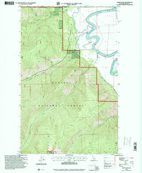
1996 Map of Smith Falls
USGS Topo · Published 1999About this map
The Kootenai River sweeps through this northern Idaho corridor where the United States meets Canada. In this mid-1990s landscape, the river’s winding course is marked by several utility structures including a Pump and a Gaging Station, illustrating the management of this vital waterway. Most of the territory is defined by the Kaniksu National Forest, with significant high-altitude landmarks such as Smith Peak, Italian Peak, and Eneas Peak towering over the drainages of Boundary Creek and Long Canyon Creek.
Find a feature on this map
22 named features on this map. Tap any name to fly to it.
Don’t see what you’re looking for? This feature index may not catch every label — zoom into the map to look around manually.
Map Details
Editions of this 1996 Smith Falls Map
This is the sole edition of this map. No revisions or reprints were ever made.
Other maps of this area

1911 · Priest Lake
USGS Topo · 1:250,000

1913 · Priest Lake
USGS Topo · 1:250,000

1958 · Sandpoint
USGS Topo · 1:250,000

1963 · Sandpoint
USGS Topo · 1:250,000

1965 · Farnham Peak
USGS Topo · 1:24,000

1965 · Copeland
USGS Topo · 1:24,000

1968 · Smith Falls
USGS Topo · 1:24,000

1969 · Pyramid Peak
USGS Topo · 1:24,000
1969 · Shorty Peak
USGS Topo · 1:24,000
1969 · Smith Peak
USGS Topo · 1:24,000