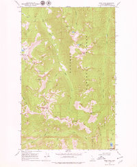
1969 Map of Smith Peak
USGS Topo · Published 1979About this map
Kaniksu National Forest defines the high-altitude landscape of this 1960s survey, dominated by the peaks and drainages of the Selkirk Mountains. The topography is marked by significant elevations like Smith Peak and The Lions Head, which overlooks the Lions Head Ridge. Water resources are central to the area's geography, with Smith Lake, Cutoff Lake, and Myrtle Lake situated among steep slopes. The West Fork Cabin stands as a rare point of human habitation in this wilderness, connected to the surrounding terrain by a network of primitive routes labeled as Pack Trail. The presence of the Myrtle Creek State Game Preserve indicates the region's importance for wildlife management and conservation during this era. The map traces the intricate drainage systems of Smith Creek and Long Canyon Creek, illustrating the natural water shed patterns of the Idaho Panhandle.
Find a feature on this map
26 named features on this map. Tap any name to fly to it.
Don’t see what you’re looking for? This feature index may not catch every label — zoom into the map to look around manually.
Map Details
Editions of this 1969 Smith Peak Map
2 editions found
Other maps of this area

1911 · Priest Lake
USGS Topo · 1:250,000

1913 · Priest Lake
USGS Topo · 1:250,000

1958 · Sandpoint
USGS Topo · 1:250,000

1963 · Sandpoint
USGS Topo · 1:250,000

1967 · Priest Lake NE
USGS Topo · 1:24,000

1967 · The Wigwams
USGS Topo · 1:24,000
1967 · Roman Nose
USGS Topo · 1:24,000

1968 · Smith Falls
USGS Topo · 1:24,000

1969 · Grass Mountain
USGS Topo · 1:24,000
1969 · Caribou Creek
USGS Topo · 1:24,000