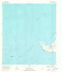
1961 Map of Smith Point
USGS Topo · Published 1977About this map
Smith Point projects into the waters where Trinity Bay and Galveston Bay meet, serving as a hub for the coastal energy and fishing industries of the early 1960s. The landscape is defined by its maritime infrastructure, featuring an extensive network of pipelines and a high density of offshore extraction points within the Red Fish Reef Oil Field and the Umbrella Point Oil Field. A glance at the shoreline reveals landforms like Morgan Pt and Trout Pt, alongside the prominent Red Fish Bar. On land, the small community of Smith Point is home to the Davis Cem, providing a focal point for genealogical research in this coastal corner of Chambers County. The map also captures the natural environment of the Vingt-et-un Islands and the essential maritime artery of the Trinity River Channel.
Find a feature on this map
32 named features on this map. Tap any name to fly to it.
Don’t see what you’re looking for? This feature index may not catch every label — zoom into the map to look around manually.
Map Details
Editions of this 1961 Smith Point Map
2 editions found
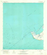
Other maps of this area

1916 · Morgan Point
USGS Topo · 1:24,000

1919 · Morgan Point
USGS Topo · 1:31,680

1929 · Texas City
USGS Topo · 1:24,000

1931 · Flake
USGS Topo · 1:24,000

1932 · Clifton By The Sea
USGS Topo · 1:31,680

1932 · Texas City
USGS Topo · 1:31,680

1932 · Bolivar Point
USGS Topo · 1:24,000

1933 · Whites Lake
USGS Topo · 1:31,680

1933 · Smith Point
USGS Topo · 1:31,680

1933 · Bolivar Point
USGS Topo · 1:31,680