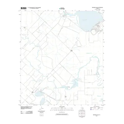
2010 Map of Smithers Lake
USGS Topo · Published 2010About this map
Smithers Lake dominates the northern reaches of this Fort Bend County landscape, where artificial reservoirs and winding watercourses define the modern topography. The map illustrates a transition from industrial and utility infrastructure near the Smithers Lake Dam to the agricultural and ranching patterns of the Texas coastal plain. Key hydrology includes the sprawling Big Creek and its many tributaries like Fairchilds Creek and Deer Creek, which weave through a network of local roads such as Ricefield Rd and Booth Line Rd. Smaller settlements and localized hubs like Whaley Corner and Long Point provide points of reference for local historians. Of particular interest to researchers of industrial geography is the Big Creek Oil Field in the west and the presence of private aviation facilities like the Flying C Ranch Airport, signaling the diverse land use in this region south of Richmond.
Find a feature on this map
36 named features on this map. Tap any name to fly to it.
Don’t see what you’re looking for? This feature index may not catch every label — zoom into the map to look around manually.
Map Details
Editions of this 2010 Smithers Lake Map
This is the sole edition of this map. No revisions or reprints were ever made.
Other maps of this area

1950 · Houston
USGS Topo · 1:250,000

1953 · Needville
USGS Topo · 1:24,000

1953 · Guy
USGS Topo · 1:24,000

1953 · Lake George
USGS Topo · 1:24,000

1953 · Damon
USGS Topo · 1:24,000

1953 · Otey
USGS Topo · 1:24,000

1953 · Thompsons
USGS Topo · 1:24,000

1955 · Sugar Land
USGS Topo · 1:62,500

1955 · Richmond
USGS Topo · 1:62,500

1956 · Houston
USGS Topo · 1:250,000