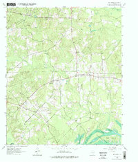
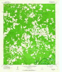
1962 Map of Smithland
USGS Topo · Published 1975About this map
The Rodessa Oil Field and numerous fossil fuel extraction points like the Gas Well in the northwest corner dominate the mid-century landscape of Marion County. Centered around the settlement of Smithland, the map reveals a dense network of country churches and family burial grounds, reflecting the deep-rooted community structure of the era. The southern portion of the sheet transitions into the swampy margins of Caddo Lake, where a complex system of waterways including Jenkins Slough, Patterson Slough, and Carters Chute surround Goat Island. Transport history is visible in the Old Railroad Grade cutting across the northeast, while the modern industrial footprint is marked by a pervasive network of pipelines crossing through the timber and creek bottoms of Kitchen Creek and Mill Creek.
Find a feature on this map
34 named features on this map. Tap any name to fly to it.
Don’t see what you’re looking for? This feature index may not catch every label — zoom into the map to look around manually.
Map Details
Editions of this 1962 Smithland Map
3 editions found
Other maps of this area

1944 · Kildare
USGS Topo · 1:62,500

1944 · Caddo Lake
USGS Topo · 1:62,500

1946 · Caddo Lake
USGS Topo · 1:62,500

1948 · Kildare
USGS Topo · 1:62,500

1956 · Tyler
USGS Topo · 1:250,000
1962 · McLeod
USGS Topo · 1:24,000

1962 · Lanier
USGS Topo · 1:24,000
1962 · Trees
USGS Topo · 1:24,000

1962 · Woodlawn
USGS Topo · 1:24,000
1962 · Smithland
USGS Topo · 1:24,000