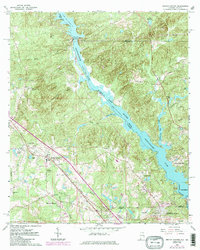
1965 Map of Smiths Station
USGS Topo · Published 1984About this map
The Chattahoochee River defines the border between Alabama and Georgia on this 1965 survey, updated in the early 1980s. The landscape is dominated by the impoundments of the Lake Oliver reservoir and the area above Goat Rock Dam. Infrastructure of the mid-20th century energy and transport sector is prominent, including the powerplant, substation, and the Central of Georgia railroad corridor passing through Smiths Station.
Find a feature on this map
51 named features on this map. Tap any name to fly to it.
Don’t see what you’re looking for? This feature index may not catch every label — zoom into the map to look around manually.
Map Details
Editions of this 1965 Smiths Station Map
3 editions found
Other maps of this area

1907 · Talbotton
USGS Topo · 1:125,000

1907 · Opelika
USGS Topo · 1:125,000

1908 · Columbus
USGS Topo · 1:62,500

1909 · Opelika
USGS Topo · 1:125,000

1914 · Seale
USGS Topo · 1:62,500

1929 · Columbus
USGS Topo · 1:48,000

1947 · Columbus
USGS Topo · 1:62,500

1949 · Columbus
USGS Topo · 1:24,000

1950 · Fortson
USGS Topo · 1:24,000

1950 · Mulberry Grove
USGS Topo · 1:24,000
Featured Places
- Columbus, GA
- Phenix City, AL
- Smiths Station, AL
- Monterey Heights, Smiths Station
- Carriage Hill, Phenix City