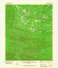
1960 Map of Smithville
USGS Topo · Published 1966About this map
Smithville sits at the northern edge of this McCurtain County landscape, where the Eagle Fork meets the rugged slopes of the Boktukola Mountains. This 1960 field-checked survey reveals a region defined by complex drainage and dense ridge networks, with the Mc Curtain County Game Preserve occupying a substantial portion of the southern central terrain. Small community hubs like Watson and Beachton are connected by winding roads and a series of stream crossings, such as those at The Narrows. For genealogists, the map preserves the locations of the Nani-chito Cem and Beechtree Cem. The presence of a Lookout Tower on Hee Mountain and a Landing Field near the southern boundary highlights the mid-century infrastructure required for managing these remote timberlands and game habitats.
Find a feature on this map
55 named features on this map. Tap any name to fly to it.
Don’t see what you’re looking for? This feature index may not catch every label — zoom into the map to look around manually.
Map Details
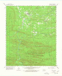
Editions of this 1960 Smithville Map
3 editions found

Other maps of this area

1890 · Poteau Mountain
USGS Topo · 1:125,000

1899 · Poteau Mountain
USGS Topo · 1:125,000

1900 · Winding Stair
USGS Topo · 1:125,000

1902 · Lukfata
USGS Topo · 1:125,000

1909 · Winding Stair
USGS Topo · 1:125,000

1913 · De Queen
USGS Topo · 1:125,000

1950 · Mcalester
USGS Topo · 1:250,000

1958 · Potter
USGS Topo · 1:62,500

1958 · Zafra
USGS Topo · 1:24,000

1959 · Page
USGS Topo · 1:62,500