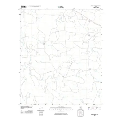
2010 Map of Smoky Draw
USGS Topo · Published 2010About this map
Rising Sun Cemetery serves as a silent focal point in this landscape of Jones County, Texas, where the terrain is defined by the ephemeral drainages of Smoky Draw and Deadman Creek. The map documents a sparsely populated ranching and industrial environment, notably featuring the Matilda Perkins Oil Field north of Threemile Creek. Private road networks like Buck Nail Ranch Rd and Chimney Creek Ranch Rd connect large landholdings including Buck Nail Ranch and Ackers Ranch. The hydrologic pattern is significant, showing the headwaters and branches of the South Prong and Spring Creek, illustrating how water access shaped the placement of local homesteads and ranching operations in this part of West Texas during the early 21st century.
Find a feature on this map
20 named features on this map. Tap any name to fly to it.
Don’t see what you’re looking for? This feature index may not catch every label — zoom into the map to look around manually.
Map Details
Editions of this 2010 Smoky Draw Map
This is the sole edition of this map. No revisions or reprints were ever made.
Other maps of this area

1891 · Anson
USGS Topo · 1:125,000

1892 · Albany
USGS Topo · 1:125,000

1893 · Albany
USGS Topo · 1:125,000

1893 · Anson
USGS Topo · 1:125,000

1954 · Abilene
USGS Topo · 1:250,000

1957 · Nugent
USGS Topo · 1:62,500
1957 · Hamby
USGS Topo · 1:24,000

1958 · Abilene
USGS Topo · 1:250,000

1965 · Acampo
USGS Topo · 1:24,000

1965 · Lueders West
USGS Topo · 1:24,000