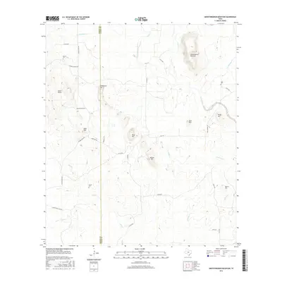
2016 Map of Smoothingiron Mountain
USGS Topo · Published 2016About this map
Smoothingiron Mountain dominates the northeastern landscape of this Llano County territory, where the Texas Hill Country transitions into a series of distinctive granite and limestone uplifts. The map details a sparsely populated ranching region defined by drainage systems like San Fernando Creek and Elm Cr, which flow through a rugged topography including Eckert Roughs and Turkeyroost Mtn. For local historians and genealogists, the placement of small, rural burial grounds such as Newsom Cem, Wooten Cem, and Koger Cem provides a direct link to the families who settled this area along the Mason and Llano county line. Transport in the region is largely defined by local routes like Union School House Rd and Hickory Grove Rd, reflecting the historical rural school and community hubs that once centered the local population.
Find a feature on this map
37 named features on this map. Tap any name to fly to it.
Don’t see what you’re looking for? This feature index may not catch every label — zoom into the map to look around manually.
Map Details
Editions of this 2016 Smoothingiron Mountain Map
This is the sole edition of this map. No revisions or reprints were ever made.
Other maps of this area

1887 · Llano
USGS Topo · 1:125,000

1887 · Mason
USGS Topo · 1:125,000

1894 · Mason
USGS Topo · 1:125,000

1894 · Llano
USGS Topo · 1:125,000

1904 · Llano
USGS Topo · 1:125,000

1909 · Llano
USGS Topo · 1:125,000

1918 · Llano
USGS Topo · 1:125,000

1954 · Llano
USGS Topo · 1:250,000

1955 · Llano
USGS Topo · 1:250,000
1955 · Magill Mountain
USGS Topo · 1:24,000