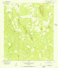
1955 Map of Smoothingiron Mountain
USGS Topo · Published 1956About this map
The Mason and Llano County boundary bisects this mid-century landscape of the Llano Uplift, dominated by granite outcroppings and prominent peaks. The terrain is defined by substantial elevations like Smoothingiron Mountain and Turkeyroost Mountain, which rise above the drainages of San Fernando Creek and North Willow Creek. Evidence of the region's geological industry is visible at the Granite Quarry near the western edge of the survey.
Find a feature on this map
23 named features on this map. Tap any name to fly to it.
Don’t see what you’re looking for? This feature index may not catch every label — zoom into the map to look around manually.
Map Details
Editions of this 1955 Smoothingiron Mountain Map
2 editions found
Other maps of this area

1887 · Llano
USGS Topo · 1:125,000

1887 · Mason
USGS Topo · 1:125,000

1894 · Mason
USGS Topo · 1:125,000

1894 · Llano
USGS Topo · 1:125,000

1904 · Llano
USGS Topo · 1:125,000

1909 · Llano
USGS Topo · 1:125,000

1918 · Llano
USGS Topo · 1:125,000

1954 · Llano
USGS Topo · 1:250,000

1955 · Llano
USGS Topo · 1:250,000
1955 · Magill Mountain
USGS Topo · 1:24,000